Measurement Network

The network will be complemented by a number of existing sites with CO2 and/or CH4 measurements of concentrations or fluxes including sites of the external pageSwiss Fluxnet program, the high alpine research site external pageJungfraujoch, the University of Bern sampling site in Bern, and several sites of the Swiss Air Pollution Monitoring Network external pageNABEL as shown in the figure below.
New cavity ringdown spectrometry (CRDS) analyzers of the company external pagePicarro (two 3-channel G2302 (CO2, CH4, H2O) and two 4-channel G2401 (CO2, CH4, CO, H2O instruments) will be deployed at the four new sites for fast and highly precise measurements of atmospheric greenhouse gas concentrations.
Concept and site description
The four measurement sites should be able to observe signatures in CO2 and CH4 concentrations caused by sources and sinks from a large part of the Swiss Plateau. The sites should therefore not be impacted by local emissions and the sampling height should be well above the surface to avoid the signatures in CO2 to be dominated by local biosphere-atmosphere exchange.
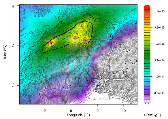
The figure below shows the so-called footprint of the four sites calculated with a Lagrangian particle dispersion model. Depending on the meteorological situation air parcels are following different pathways before they reach one of the four measurement sites. We have simulated these pathways for a complete year and averaged them together to determine a mean footprint as shown in the figure. The footprint represents the residence time of air parcels close to the surface and is a measure for how much the concentration at one of the four sites changes when a unit mass of CO2 or CH4 is released from a given point. Red colors indicate high sensitivity to emissions, blueish colors little sensitivity. The black circle encloses the area with highest sensitivity and is our main target domain.
An ideal site would be a very tall tower over flat terrain but such a tower is not available and compromises have to be found. The following four sites have finally been selected:
Beromünster radio tower
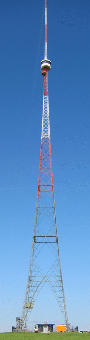
This 217 m tall tower, also known as Blosenberg tower, was built in 1937 and has been in use as radio transmission tower until 2008. It is a protected historical monument and the third tallest tower construction in Switzerland.
Its basement is located at 797 m a.s.l. on a smooth hill surrounded by agricultural land, a patch of forest about 700 m to the south, and 2 km to the southwest of the village of Beromünster. The only potential local contamination source is a farmers' house 170 m to the east. There are no major roads in its proximity.